Thank you for your patience as we rebuild our website! 2020-2025
The “Remembering Shared Honor” (RSH) project sets out to collect and preserve oral histories related to Chinese and American cooperation during the Second World War in the China-Burma-India(CBI) theater of war.
This historical archive has a total of 7,078 entries.
Bombing of Phủ Lý railway bridge in French Indochina (Vietnam), during WWII. In northern Vietnam, and along a critical rail route used by the Japanese.
Bombing of Phy Ly railway bridge in French Indochina (Vietnam), during WWII. In northern Vietnam, and along a critical rail route used by the Japanese.
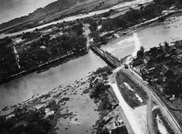
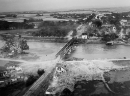
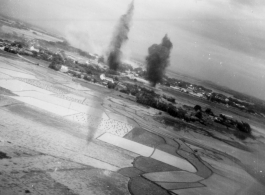
Bombing on Phu Lang Thuong railway bridge over the Thuong River at Bắc Giang City in French Indochina (Vietnam), during WWII. In northern Vietnam, and along a critical rail route used by the Japanese. Coordinates: 21°16'32.69"N 106°11'9.28"E
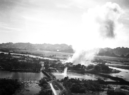
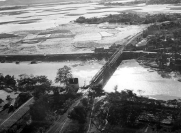
Bombing on Phu Lang Thuong railway bridge over the Thuong River at Bắc Giang City in French Indochina (Vietnam), during WWII. In northern Vietnam, and along a critical rail route used by the Japanese. Coordinates: 21°16'32.69"N 106°11'9.28"E
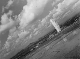
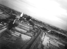
Bombing on Phu Lang Thuong railway bridge over the Thuong River at Bắc Giang City in French Indochina (Vietnam), during WWII. In northern Vietnam, and along a critical rail route used by the Japanese. Coordinates: 21°16'32.69"N 106°11'9.28"E
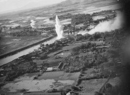
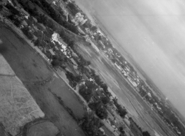
Bombing on Phu Lang Thuong railway bridge over the Thuong River at Bắc Giang City in French Indochina (Vietnam), during WWII. In northern Vietnam, and along a critical rail route used by the Japanese. Coordinates: 21°16'32.69"N 106°11'9.28"E
Bombing on Phu Lang Thuong railway bridge over the Thuong River at Bắc Giang City in French Indochina (Vietnam), during WWII. In northern Vietnam, and along a critical rail route used by the Japanese. Coordinates: 21°16'32.69"N 106°11'9.28"E
Bombing on Phu Lang Thuong railway bridge over the Thuong River at Bắc Giang City in French Indochina (Vietnam), during WWII. In northern Vietnam, and along a critical rail route used by the Japanese. Coordinates: 21°16'32.69"N 106°11'9.28"E
Bombing on Phu Lang Thuong railway bridge over the Thuong River at Bắc Giang City in French Indochina (Vietnam), during WWII. In northern Vietnam, and along a critical rail route used by the Japanese. Coordinates: 21°16'32.69"N 106°11'9.28"E
Bombing on Phu Lang Thuong railway bridge over the Thuong River at Bắc Giang City in French Indochina (Vietnam), during WWII. In northern Vietnam, and along a critical rail route used by the Japanese. Coordinates: 21°16'32.69"N 106°11'9.28"E